Recently added item(s)
No products
Product successfully added to your shopping cart
There are 0 items in your cart. There is 1 item in your cart.
Maps of Occitania
- New Selection
- Books
- Music
- Videos - DVD
- Miscellaneous
- Revues, Journaux
Links
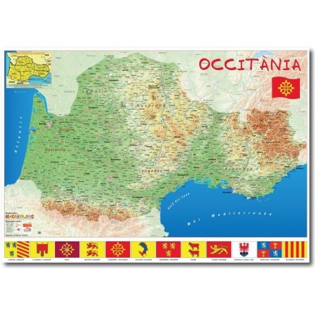
Occitanie Map (Occitania) 70 x 100 cm

OBJ-Mapa_70x100
New
Not sure
8,00 €
Occitanie Map - Carte de l'Occitanie - Map of Occitania: physical geography of Occitània, with toponyms, in paper 70 x 100 cm (Macarel).
Data sheet
| Type | Paper map |
| Language | occitan |
| Format | 70 x 100 cm |
| Distributor | Macarel |
More info
Physical geography map of Occitania (70 x 100 cm)
Carte de géographie physique d'Occitanie
Find more than 1400 names in Occitan language: cities, county towns + major tourist sites and main roads, rivers and soils in Occitan.
For your information, Occitania is a linguistic, cultural and historical region of Southwestern Europe (covering approximately the southern third of France and border regions of three other countries). Discover on this printed map the entire geographical area of Occitan, the dialects of the Occitan language, the flags of the historical regions, and the original place names in Occitan.
Full color map on 180 grams glossy paper, shipped rolled in a cardboard box. Size: 70 x 100 cm
Manufacturer: Macarel.
Reviews
No customer comments for the moment.
Customer reviews
La carte n'est pas très détaillée pour cette région. Si vous pouvez me suggérer un site web où je pourrais trouver des cartes détaillées de la France, j'en serais ravi.
 Merchant's answer
Bonjour Guillermo,Merci pour votre retour sur notre site "Espaci Occitan dels Aups". Nous prenons en compte vos remarques concernant la carte et cherchons toujours à nous améliorer. Si vous cherchez un article cartographiant l'espace réel de toutes les régions occitanophones, aucun fournisseur ne pourra, à ma connaissance, nous faire une proposition en occitan plus détaillée dans le format 70x100cm. Il vous faudra certainement segmenter les espaces linguistiques (Lemosin/Languedocien/Gascon/Vivarais/Provençal etc.) ou rechercher une carte bien plus grande. Pour des cartes détaillées de la France, je vous recommande de consulter le site Géoportail (geoportail.gouv.fr), qui offre de nombreuses ressources cartographiques.Pour rappel, "l'Espaci Occitan dels Aups" est une librairie associative et non pas une société de cartographie : nous ne sommes pas les éditeurs de la présente carte, comme l'indique la fiche-produit de cet article : https://www.espaci-occitan.com/botiga/fr/mapas-d-occitania-cartes-d-occitanie/487-carte-occitanie-macarel-70-x-100-cm-9999000000439.html
La granda carta es un pauc torçuda a un canton. Mas 'quò irá entau.
très bien
 English
 Français
 Occitan


