English
 Français
 Occitan
Recently added item(s)
No products
Product successfully added to your shopping cart
There are 0 items in your cart. There is 1 item in your cart.
Maps of Occitania
- New Selection
- Books
- Music
- Videos - DVD
- Miscellaneous
- Revues, Journaux
Links
") View larger
View larger ")
")
")
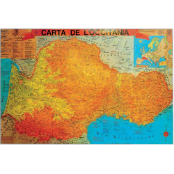
Carta de l'Occitània - Occitania map 60 x 90 cm (Aici e ara)
OBJ-9999000000289
New
10 Items
Available
8,00 €
Carta de l'Occitània - Occitania map : geography of the Occitan linguistic area, with toponyms (cities, regions, valleys, countries), in glossy paper 60 x 90 cm (Aici e ara). Chambra d'Òc.
Data sheet
| Type | Paper map |
| Year | 1981 |
| Language | occitan |
| Format | 60 x 90 cm |
| Distributor | Chambra d'Òc |
| Label | Aici e ara |
More info
Carta de l'Occitània - Occitania map 60 x 90 cm (Aici e ara)
Find more than a thousand names in Occitan: cities, towns, valleys, main roads, rivers and terroirs in Occitan.
For your information, Occitania is a linguistic, cultural and historical region of Southwestern Europe (covering approximately the southern third of France and border regions of three other countries). Discover on this printed map the entire geographical area of Occitan and the original Occitan place names.
For a long time France was divided into northern France, where the word for "yes" was oui, and southern France, where the word for "yes" was oc. The south became known as Occitania. The people there spoke Occitan and not French. Occitania stretched from Bordeaux to the Italian border, from Narbonne to Clermont-Ferrand.
Color map on glossy paper, size 60 x 90 cm, shipped rolled in a cardboard box.
Manufacturer: Aici e ara.
Distributed by Chambra d'Òc (Italy).
Reviews
No customer comments for the moment.